Often Overlooked Drone Explanations
by Robert Haskell
With all the hype about drones in the air these days, there are some common explanations that often get overlooked. Of course there is no single explanation for everything as drone sightings are likely due to a number of factors including misidentified but known conventional aircraft, hobbyists overstepping their bounds and even some experimental military aircraft. Optical illusions can also occur through temperature inversions and lighting conditions at times will affect what we see. Unfortunately, the humane eye is not very good at deciphering many of these illusions. Nevertheless, there are common explanations for some of these sightings that usually get overlooked.
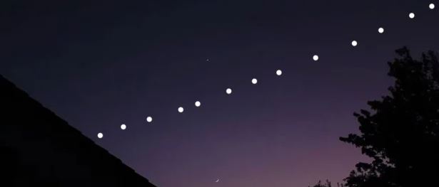
Starlink is a series of satellites that orbit the planet. This program run by Elon Musk (part of SpaceX) aims to bring high speed internet to places where internet is lacking. When Starlink is overhead, it appears usually as a linear progression of bright lights that can easily be mistaken for drones. Having witnessed these once myself, they really are an incredible site. They move smoothly and silently across the sky because they are actually orbiting Earth at 300 miles. You can see whether or not Starlink is in your area at findstarlink.com.
There is nothing nefarious here at least in this case. There may very well be a few bad actors out there whether it be rogue idividuals playing tricks on people or actual state sponsored low-tech spycraft but by and large, many of these sightings can be explained as known objects in the sky even if the public is not familiar with them.
There are some objects that are harder to explain like larger drones the size of cars appearing over local neighborhoods. I managed to catch this as well a couple of times and assumed it was either my rich neighbor playing with a new toy or some legitimate research project. The U.S. government studies for example existing waterways for agricultural safety concerns and disaster preparedness. This type of research must be conducted though it probably would not be a bad idea for the FAA (Federal Aviation Administration) to require drone hobbyists and those doing research to file a publically searchable flight plan especially when flying at night. A four question survey posted in an app that simply states where the flight will occur, the time, date and purpose would not be too burdensome and probably alleviate much of the anxiety that started a few years ago when the FAA began to allow night flying drones.
For those concerned about privacy, this would not really be an issue either provided the drone operator was only identified in the registry by a device number. This unique identifier would then be saved in the app so the user only has to enter it once. The cost to implement this service would be nominal as long as they kept it simple. I would break it down by time and geographic region. For example, new_york_may_10_xxxx would store just the flights made that day in NY. The relatively small tables would keep data management costs down and the whole program could probably be operated on a shoestring budget.